
Our house in 1936
We do, however, have a nice view of Vermont. A dear old friend who lived across the river some years back used to proudly say that the folks over on this side were lucky because they got to look at Vermont. I tend to agree with her.
In 1762, New Hampshire Colonial Governor John Wentworth issued grants to 64 persons in what are now the towns of Monroe and Lyman. They were obligated to clear, farm and settle one tenth of each of their parcels or forfeit their grants. Only two even made the attempt.
One of them was Colonel John Hurd of Portsmouth. He was granted a parcel of land that included the riverbank and five small islands. It was named Hurd’s Location.
The first known settler was John Hyndman, who built a log cabin and settled with his wife and son on the largest of the islands in 1784. He was followed by Joseph, Timothy and Israel Olmstead along with their wives and children.
Twenty-three of the parcels were combined with Hurd’s grant to become West Lyman. In 1854, it was incorporated as a separate town and renamed Monroe after the fifth president.
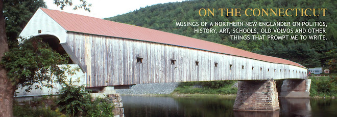
There once were two long covered bridges that connected Monroe with the town of Barnet, Vermont, which is right across the river from us.
The lower or Lyman Bridge connected Monroe Center with McIndoe Falls, the biggest of Barnet’s five villages. It was the third bridge on this site. More than 300 feet long, it was built as a toll bridge in 1833 by Peter Paddleford, a Monroe resident and inventor of the Paddleford Covered Bridge Truss.

The Lyman covered bridge
After 96 years of continuous use, the bridge was still in good condition when it was dismantled in 1930 and sold to Julius Long for a barn. It was replaced with an arched, steel truss bridge.
The upper or Beard’s Falls bridge was the fifth bridge on that site. The first four were lost to weather or flood.
It was a 220-foot Town lattice with arch structure and built as a toll bridge by Phillip Henry Paddleford of Monroe in 1877. It was condemned and replaced by the current steel truss bridge in 1938.

The Beard’s Falls covered bridge

The Beard’s Falls bridge toll gate
The completion of the Connecticut and Passumpsic Railway line in 1850 connected Monroe and MacIndoe Falls with the outside world. It also opened urban markets to area businesses.
McIndoe Falls was named for the natural falls that stretched across the river between Barnet and Monroe. They provided water power for a large sawmill on the Vermont side and a large grist mill on the New Hampshire side. Both are long gone.

McIndoe Falls from Monroe near the beginning of the 20th Century. The sawmill is on the left of the falls and the gristmill on the right.
Built in about 1875, George VanDyke's sawmill was the largest lumber mill in northern Vermont. It employed more than 100 men and manufactured about 15,000,000 feet of lumber per year.
H.P. Hood and Sons, a Boston Milk company, ran a huge icehouse in McIndoe Falls in the early 20th Century. Every winter in January or February, depending on weather, the river ice was cut into large blocks for shipping to Boston to refrigerate the Hood plant.
Over in Monroe, Charles McFarland's gristmill, built around 1840, had five runs of millstones and handled about fifty car-loads of western grain per year. Eber A. Willey's butter-tub factory, built in 1884, ran on steam-power and had the capacity for manufacturing 10,000 butter-tubs per year.

McIndoe Falls some time before 1930.
Between 1928 and 1930, a dam and hydro-electric generating station were built on McIndoe Falls. It currently generates about 11 MW of electricity. We can hear the roar of rushing water inside our house when they open the gates to lower the water level.

The new hydro-electric dam and steel truss bridge in the 1930s.
Things up here don’t look all that much different than they did when the above photo was taken. The biggest change is the hillsides are now heavily forested. The upper valley’s hillside pastures are rapidly filling in. Our lovely views are disappearing.

No comments:
Post a Comment